Last fall, I described the pleasure of kayaking and hiking around Newcastle Island Provincial Park, within sight of Nanaimo B.C. The next day of my visit, my goal was Gabriola Island, the big island on the north end of the Gulf Island chain. While most American cruisers make a stop in Nanaimo on their way to or from Desolation Sound and points north, the indented south-east end of Gabriola rarely gets any attention, and I wanted a closer look. For this trip, my vehicle was my touring bicycle, which I hoped would allow me to cover all the island’s harbors in a single day via the 19-mile loop road.
It’s a short ferry ride from Nanaimo about three miles to Descanso Bay–a steep-sided cove whose name comes the Spanish word for “rest”–given by the Spanish explorers Galiano and Valdes when they anchored their schooners (the Sutil and the Mexicana) there on June 14, 1792. The road inland is dominated by a long line of “vintage” cars that have seen better days and are left on the island by the locals when they commute to Vancouver Island.
All the island’s limited commercial development is concentrated along the road from the ferry landing, so I was quickly out in the countryside with little traffic on a weekday. I rolled past fields and orchards that appeared to date from the island’s pioneer years, which really lasted into the 1950s, when the population was still only a few hundred. Until then, the only notable development based on the sandstone rocks that underlay Gabriola’s rolling hills, now hidden back in the woodlands.
The Island’s Prized Sandstone
Beginning in the 1890s, prized sandstone blocks were cut from a quarry here and shipped for architectural use in Victoria and other cities, while a brickyard produced 80,000 high-quality bricks a day. In the 1930s, a new use was found for the sandstone: it was turned into millstones for grinding wood pulp and sent to paper mills as far away as Finland. In the grounds of the Gabriola Museum, there are a number of rock-cutting machines and mill stones on display. (The informative website is www.gabriolamuseum.org –check for their hours before visiting.)
Today, the resident population is about 5,000, ten times what it was in the early 60s. In summer, the island’s population increases even more, attracting families with the simpler, rural life and many festivals featuring music, art, and even boat building. In search of some of this island culture, I followed the road south to Silva Bay for eight miles, enjoying glimpses of Vancouver Island’s mountains across the waters of the Northumberland Strait.
In World War II, the shipyard at Silva Bay became the major employer, building wooden minesweepers for the Canadian Navy. The post-war years saw this short stretch of naturally-protected shore grow into a popular yachting center with a range of moorages, marinas and services. The third phase of the island’s development took off in the 1970s, when the island became a magnet for young people escaping the urban life and going “back to the land.” One lasting effect of that wave of migrants is the number of artists who live and work here. There are dozens of potters, painters, woodcarvers, jewelers, weavers etc spread all around the island.
By now I had slowed down and was noting all the dead end roads running down to the water. I finally decided to try the turn-off to Degnen Bay. I found this was filled with mooring buoys and a short government dock close to shore. There is an excellent anchorage here, but no services. Pleased with my discovery, I was soon off on another detour, on a dirt road, to Drumbeg Provincial Park. The road wound through an endangered Garry oak ecosystem opening onto a tranquil cove where shelving sandstone ledges pockmark the shoreline and overlook Gabriola Passage. The park is a favourite spot for swimming, fishing, picnicking and sunbathing.
Silva Bay’s Shipyard, Boatbuilding School and Marinas
Now I must admit that I had been at the Port Townsend Wooden Boat Festival a few days before, so I was pleased to to find my next turn-off brought me the Silva Bay Shipyard. It was a pleasant surprise to stop in front of the old workshops built on pilings. The shipyard was established in the late 1930s, boomed during WW II, and became a flourishing business building fishboats again in the late 1940s. Many launches and patrol boats for the Canadian government went down the ways in the 1950s, followed by a dozen or so Fleetwing outboard cabin cruisers fitted with the tail fins like the cars of the day.
The largest pleasure craft ever built at shipyard was the Cee-Aer, 65 feet long, 17.4 feet wide, and powered by two 300-hp Cummins diesel engines, launched on September 9, 1968. The yard changed hands, but continued new construction into the 1970s, then began to modernize into a maintenance facility with a marine railway,and the first Travelift in western Canada. (To read a fascinating complete history, Google “Withey Shipyard.”)
The coves and a chain of islands form a superb natural harbor here (or “harbour” as Canadians spell it). Working my way long the shore, I came next to Page’s Resort and Marina, which has practically every amenity you could dream of: a full service marina with “quiet nightly moorage,” a marine book and chart store, fully equipped seaside cottages, a pristine campground offering ocean views, and best of all a mountain bike/motor scooter rental store so you too can ride the backroads! (To read another complete family history since the 1930s, go to www.pagesresort.com/history.html
Next along the shore, we come to the Silva Bay Resort & Marina, with more excellent facilities including a pub and tennis courts, and the restored Silva Bay Inn with its beautiful garden sloping down to the waterfront–”the perfect place to slow down, unwind, and enjoy the spectacular views,” the owners claim. Wherever you moor in the bay, you can explore the beautiful Flat Top islands In your own dinghy or kayak. These islands act like a giant natural breakwater, giving the bay incredible protection from all directions, which is why the Royal Vancouver Yacht Club has a private out station here at Tugboat Island.
Folklife Village—a Unique Shopping Center
It was late in the afternoon when I began the haul back on the North Road through dense forest, until I suddenly emerged back in the bustle of the Folklife Village, at the island’s main junction. This is Gabriola’s shopping center with a dozen stores from an art gallery to movie rentals. (No visit would be complete without a visit to one of their studios.)The name, and the striking design, come from its original design as the Folklife Pavilion at Expo 86 in Vancouver.
It was a masterpiece of post-and-beam construction that was intended to be dismantled and re-built. But it took at least 20 huge truck-loads winding off the ferry and along some narrow stretches of road to get the huge timbers and walls to their new home. Putting it all back together in a form adapted for commercial use and able to pass local building codes was no mean feat.
Malaspina Galleries—a Natural Wonder
It was a toss-up between window shopping here or following my tourist map a little further to a site on the island’s north-west corner that seemed worth investigating. This turned out to be the most memorable experience of the day. I came upon a rustic sign to a community park and followed the trail that led out to the shore and a point of land jutting north. It ended in a sandstone bench; on the west side was a fantastic and bizarre rock formation called the “Malaspina Galleries.”
The soft sandstone has been eroded over untold years into a delicate overhanging shape literally like a curling wave. This crest looks ready to crash down on any unlucky “surfer” caught inside the curl, so there are warnings to keep out. It looks feasible to moor nearby in Taylor Bay, which has a public beach, then walk or dinghy around, but check your chart first. (This formation was sketched by Jose Cardero of the Mexicana, but his directions were vague and this spot was over-looked by geographers until 1903.)
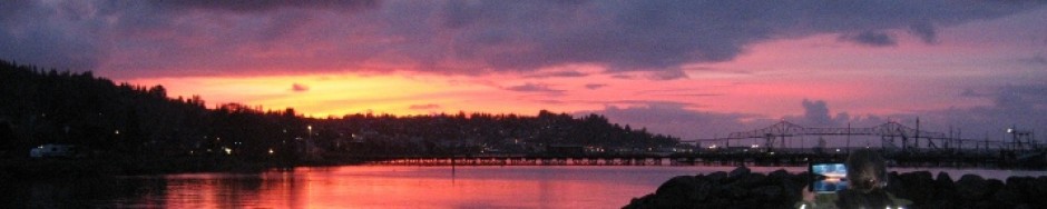
With the sun setting and the unforgettable image of the galleries on my mind, I turned back for the short ride to the ferry terminal. As I watched the ferry enter the bay, I could only wonder at my day that had revealed a few of the island’s secrets, and given me the desire to see more—when I return in my own boat…
If you go, start your research at www.gabriolaisland.org run by the chamber of commerce–the most complete guide to the island.